Great and Small Circles - SS3 Mathematics Lesson Note
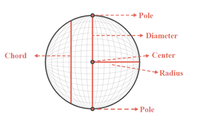
Consider these models of a sphere,


The following can be observed:
-
The north and south poles at opposite ends of the polar axis running through the center
-
The radius of the sphere
-
The horizontal plane through the center and perpendicular to the polar axis called the equator
GREAT CIRCLES: LINES OF LONGITUDE and THE EQUATOR
SMALL CIRCLES: PARALLELS/ LINES OF LATITUDE
Longitude lines, known as meridians, are fictional divisions on the Earth that extend from the North Pole to the South Pole, determining the distance in the east-west direction.
The prime meridian, passing through Greenwich, England, holds a longitude of \(0{^\circ}\) degrees. It serves as the reference point dividing the Earth into the eastern and western hemispheres. The antemeridian is located on the opposite side of the Earth at \(180{^\circ}\) degrees longitude. The antemeridian plays a significant role as the foundation for the International Date Line.

Parallels, also known as lines of latitude, are fictional lines that divide the Earth, extending in an east-west direction and measuring your position in the north-south direction. The equator, the most famous parallel, plays a central role as it splits the Earth equally into the Northern and Southern hemispheres at \(0{^\circ}\) degrees latitude. As you move away from the equator towards the poles, latitude increases, reaching \(90{^\circ}\) degrees at each pole.
Various other lines of latitude are named based on the sun's position during Earth's orbit. These lines assist in understanding climate, weather, and ocean currents. The Tropic of Cancer, approximately at \(23{^\circ}\) degrees north, and the Tropic of Capricorn, approximately at \(23{^\circ}\) degrees south, define the boundaries of the tropics. The Arctic Circle and the Antarctic Circle are positioned around \(66{^\circ}\) degrees north and south, respectivelY, serving as demarcations for the Arctic and Antarctic regions.
Each degree of latitude corresponds to approximately \(111\ kilometers\) on the Earth's surface. A degree of latitude can be further divided into \(60\ minutes\), and each minute can be divided into \(60\ seconds\). Consequently, a second of lat\(itude\ covers\ only\ about\ 30.7\ meters\). Unlike lines of longitude that converge towards the poles, lines of latitude remain parallel. Irrespective of your location on Earth, the distance between lines of latitude remains consistent.
Every point on the earth’s surface can be defined by a coordinate of its longitude and latitude. For Example, Zuma Rock in Abuja has a coordinate of \(9{^\circ}N,\ 7{^\circ}E\), meaning it is \(9{^\circ}\) north of the equator (latitude) and \(7{^\circ}\) east of the Greenwich/Prime meridian (longitude).
